 English
>
Site Profile
>
Site Profile
Site Profile
English
>
Site Profile
>
Site Profile
Site Profile
Brief Introduction
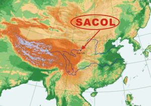
Arid and semi-arid areas comprise about 30% of the earth's surface. Changes in climate and climate variability will likely have a significant impact on these regions. The Loess Plateau over Northwest China is a special semi-arid land surface and part of a dust aerosol source. To improve understanding and capture the direct evidence of the impact of human activity on the semi-arid climate over the Loess Plateau, the Semi-Arid Climate and Environment Observatory of Lanzhou University (SACOL) was established in 2005. SACOL consists of a large set ofinstrumentsand focuses on: (1) monitoring of long term tendencies in semi-arid climate changes; (2) monitoring of the aerosol effect on the water cycle; (3) studies of interaction between land surface and the atmosphere; (4) improving the land surface and climate models; and (5) validation of space-borne observations.
Location and climatology
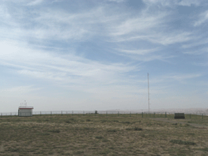
Yuzhong Observatory is about 48 km away from the center of Lanzhou, situated at the southern bank of the Yellow River in the Gansu province in Northwest China (35.57±N, 104.08±E). It is situated on the China-Loess Plateau, about 1965.8 m above sea level. The topography around the site is characterized by the Loess Plateau consisting of plain, ridge and mound, etc, with the elevation ranging between 1714-2089 m. The parent soil material is mainly quaternary aeolian loess with the main soil type being sierozem. There is also some loess soil in the terrace, ridge and mound. The terrain where the measurements are carried out is flat and covered with short glass. The dominated species within the immediate area are stipa bungeana as well as artemisia frigida and leymus secalinus.
Annual Mean Parameters
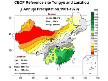
Precipitation: 381.8 mm
Evaporation: 1326.3 mm
Relative Humidity: 63%
Wind Speed: 1.6m/s
Sunshine Hours: 2607.2h
climate and environment
atitude:35.946N
longitude:104.137E
Elevation: 1965.8 m
Land Cover: moderation
Surface Type: loess tableland, ridge, hillock and gully
Water and energy cycles are extremely important in understanding the mechanism of climate and environmental change in China because of the severe short-age of water resources and the rapid increase of population, which lead to a significant anthropological impact on the climate and environment due to land-use and greenhouse gas emissions. Anthropogenic emissions of greenhouse gases cause an increase in surface temperatures (the “greenhouse effect”) and can have profound effects on the climate and thus on societal welfare. Brought on by more than a factor of 5, the increase in human population and the subsequent activities of mankind over the last century or so, green-house gases and aerosols produced by the combustion of fossil fuels, industrial activities, and land use have altered the atmospheric composition so that it is not the same as it was a century ago (Mann et al., 1999; Crowley, 2000; Houghton et al., 2001). The resulting increase in surface temperature over this period is estimated to be between 0.4±C to 0.8±C (Houghton et al., 2001). Aerosol particles also have a major influence on the global climate and climate change; they can locally either intensify or moderate the effects of the greenhouse gases through the scattering or absorption of both incoming solar radiation and thermal radiation emitted from Earth's surface. Aerosols also act as cloud condensation nuclei (CCN) and thereby modify the radiative properties of clouds (Twomey, 1977). There is substantial uncertainty regarding the magnitude and spatial distribution of aerosol radiative forcing. Ramanathan et al. (2001) suggested that a combination of the aerosol direct and indirect effect can weaken the hydrological cycle, which could be a major environmental issue in this century.
Some field experiments have recently been carried out over the arid and semiarid regions of China over the past 30 years, for example HEIFE (Hu, 1994; Hu and Gao, 1994), IMGRASS (Lu et al., 2002, 2005), NWC-ALIEX (Huang, 2004; Zhang et al., 2005; Bao and Lu, 2006), dust aerosol observations in Dunhuang (Iwasaka et al., 2003, 2004), surface layer turbulent flux observations over Naiman (Zhang et al., 2001) and Tongyu (Liu et al., 2004), etc., in which a great deal of observational data and research achievements were gained. However, there was little learned of the Loess Plateau and there was no international long-term observation site for the Loess Plateau. Loess Plateau is the largest arid and semi-arid zone in China and is also one of the dust aerosol sources. To fill this gap and improve understanding of the impact of human activity on semi-arid climate over the Loess Plateau, the Semi- Arid Climate & Environment Observatory of Lanzhou University (SACOL) was established in 2005. This site is nearby the city of Lanzhou, at the southern bank of the Yellow River in northwestern China. In addition, the site is very close to the geometric center of China's mainland. This region includes many types of aerosol particles of widely varying composition and sizes de- rived from one of the largest aerosol source regions on the earth. SACOL makes several important measurements of wind-blown dust, urban pollution, and radiation properties. SACOL is specifically designed to assess the dust aerosol effect on local climate as well as the global climate. Most of the instruments in SACOL are based at the BSRN, CEOP, AERONET and MPLNET. The main focus of SACOL is on assessing and improving the new data products being derived from these instruments to increase our knowledge and reduce uncertainties associated with atmospheric aerosols and their radiative impacts. SACOL also plays a critical role in testing and improving the satellite algorithms over the Loess Plateau because of the unusually complete datasets that are obtained to characterize properties of the atmosphere and surface. Furthermore, the measurements provide details about aerosols, such as particular height-resolved aerosol radiative and microphysical properties, some of which cannot be retrieved from any current or anticipated satellite data; these data are a test bed for current aerosol and chemical transport models.
 An Overview of the Semi-arid Climate and Environment Research Observatory over the Loess Plateau(PDF, 2960K)
Address:22nd floor, guanyun building, no. 222, tianshui south road, lanzhou city, gansu province
Postcode: 730000
Tel: 0931-8915610
